

Update Thursday, March 18: Hall emergency management officials say the serious storms forecast for the area have developed weaker than expected.
“We have not seen any significant issues in Hall County,” Hall County Emergency Management Director Casey Ramsey said around 7:30 a.m. “There still remains a threat for a few isolated severe storms to move through over the next couple of hours, but we do not expect any significant issues to result from those storms.”
Ramsey said citizens should still remain “weather aware” as they’re beginning their morning commutes.
The Hall County School District posted on social media that it will operate on a normal schedule today.
“The National Weather Service and the Hall County Emergency Management Center tell us severe weather did not develop in Georgia. Rain is expected until 10:00AM or shortly thereafter, but the dangerous storms that were to the west have not developed in our area,” according to the post.
Previous story as of Wednesday: A line of thunderstorms are forecast to move through Gainesville and Hall County Thursday morning, bringing the potential for tornadoes and large hail, according to the National Weather Service.
Kyle Thiem, meteorologist at the National Weather Service’s Peachtree City office, said the thunderstorms are expected to pass through the area between 6 and 11 a.m. Thursday.
“We’re expecting we could have some widespread severe threats,” Thiem said. “We could have strong damaging winds, maybe some large hail. Some tornadoes will be possible as well.”
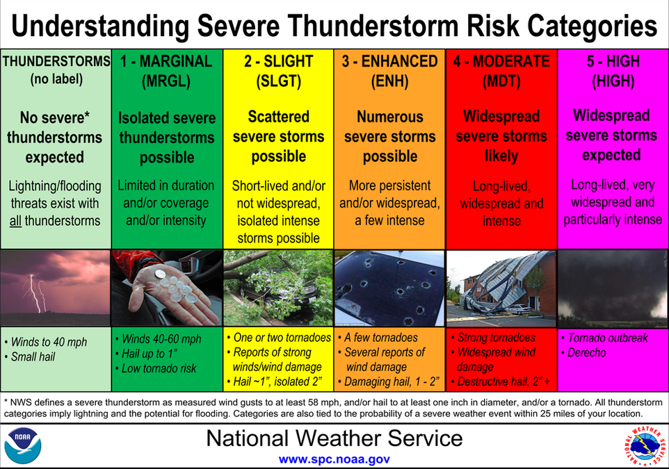
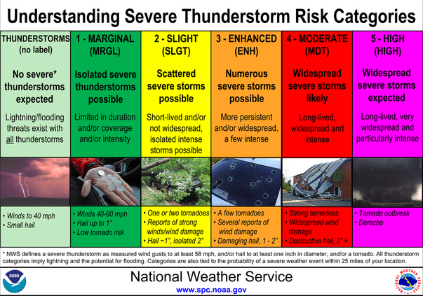
Hall County Emergency Management Agency Director Casey Ramsey said the storm coming through the area is in the Level 3 category, meaning that Hall is at an “enhanced risk” of numerous severe storms. This includes a few tornadoes, reports of wind damage and hail reaching 1-2 inches in diameter.
Ramsey said Hall could see up to 60 mph winds Thursday morning and a collective 1-2 inches of rain by the time the storms pass.
“What concerns us anytime we have significant wind values is downed trees and power lines,” he said. “We’ll (emergency management) make sure when we have those instances to get the roads clear. As a reminder, stay away from downed power lines.”
Ramsey noted that Hall has 22 weather sirens in the county. If there is a tornado warning in an area with a siren, it will sound an alarm.
Ramsey reminded residents that the sirens are intended to alert people outside. If someone is inside, they might not be able to hear one go off. He advises Hall residents to keep a weather alert at the ready on their phones. People can sign up for the emergency management agency’s citizen alert system — which notifies residents about severe weather events — by visiting alerts.hallcounty.org.
The latest outlook slightly expands the High risk area and increases the underlying likeliehood of tornadoes across the southeast.
— National Weather Service (@NWS) March 17, 2021
Multiple rounds of storms are possible. Keep your devices charged so you are able to recieve warnings from later rounds if you lose power. https://t.co/9oK0Ab82hO
If a tornado does touch down, Ramsey asks that people seek refuge in the center of the lowest point of their home, like a basement. If someone lives in an apartment complex, he recommends moving to the ground floor or an interior stairwell. Those who reside in a mobile home should prepare to stay with a neighbor or relative who lives in a safer structure, he said.
“Now is a good time to make sure your plans are in place,” Ramsey said. “Have your phone charged up. Be prepared and pay attention.”
Habersham schools announced Wednesday afternoon that the system would operate on a three-hour delay Thursday.
The Associated Press contributed.