
SEND US YOUR SNOW PICTURES
We want to share your snow pictures with our readers. E-mail them to us at news@gainesvilletimes.com. Or upload them yourselves in the community section of our Web site. (See reader pictures.)
National Weather Service forecast:
Today: Sunny, with a high near 42. Northwest wind between 10 and 15 mph, with gusts as high as 20 mph.
Tonight: Mostly clear, with a low around 18. Northwest wind between 5 and 10 mph.
Tuesday: Sunny, with a high near 46. North wind between 5 and 10 mph, with gusts as high as 15 mph.
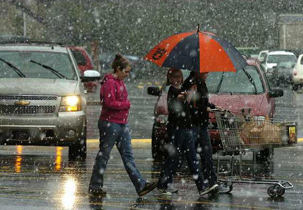
Sunday started with rain, which turned into heavy snowfall after lunch, and then finished off with wind and a bright but brief sunset, yellow rays reflecting off downtown Gainesville offices.
The winter's first snowstorm blew through Georgia Sunday, causing havoc from LaGrange and Columbus to Athens, dropping various amounts of snow - 2 to 5 inches - along the way.
The storm produced a flurry of church and school closings, and the possibility of more to come early this morning as the region deals with the threat of icy roads. DOT crews will monitor road conditions overnight.
Counties north of Hall, normally the worse victims of a winter storm, got a break this time, with mostly rain and flurries here and there. But areas to the east of Hall County took some of the worst of the storm, getting as much as 5 inches of snow.
Jackson County was one of the hardest hit areas and local officials declared to a state of emergency. Schools and county government offices are closed today, according to a news release from Jackson County Emergency Services.
Sheriff's Maj. David Cochran said the county was dealing with multiple accidents, power outages and debris in roadways. Clearing those accidents was the sheriff's department's main concern on Sunday night, he said. The Jackson County emergency director couldn't be reached Sunday night.
Late Sunday, about 13,800 Jackson Electric Membership Corp. homes were without power in Jackson and Barrow counties, said Bonnie G. Jones, a spokeswoman for Jackson EMC.
Georgia Power reported only a handful of outages in the Gainesville area, though the company had dealt with more than 10,000 outages statewide.
North Hall and the North Georgia mountains were spared much of Sunday's snowfall, while several inches of snow smacked areas farther south, from Gainesville to Flowery Branch and Buford, said Patricia Atwell, a meteorologist with the National Weather Service in Peachtree City.
Some areas, such Athens and Oconee and south Jackson counties, were pounded even harder, up to 5 inches, because of a low-pressure system that began over Columbus early Sunday, Atwell said.
Athens "is kind of on the pivot point" of the system, she said.
"As that low goes across overhead, it's got really cold air aloft so it's inducing some thunderstorms," Atwell said. "And where we get what we call ‘thundersnow,' (areas) get much more snow in a 10- to 15-minute period."
Statewide, the situation wasn't as bad as it could have been, Ken Davis, a spokesman for the Georgia Emergency Management Agency said.
"We're lucky it happened on the weekend," Davis said.
GEMA officials were continuing to monitor the conditions late Sunday, fearful that overnight temperatures in the 20s could make this morning's commute dangerous. The weather service said any water, slush or snow remaining on roads would freeze overnight making roads hazardous. Bridges and overpasses are the first to become icy.
But winds picked up late Sunday. Davis said those high winds could be beneficial because they could dry roads and bridges before they freeze.
"It's a good thing that the precipitation stopped around nightfall, because it will give the wind a chance to help us," he said.
At 8:30 p.m., the temperature in Gainesville was 36 degrees, but it was expected to drop to 25 degrees by morning.
The situation will improve by mid-morning today as temperatures rise above freezing. Today's high temperature will be around 40 degrees.
While officials were left to worry about the snow and ice, for many, Sunday was a day of fun. And for the younger set, dreaming about school being closed today would be the perfect touch to a day filled with playing in the wet snowball-friendly precipitation.
"It's cold and fun," said 11-year-old Jahzeel Penaloza, playing with four other children outside their Simmons Street home.
Sledding was the pastime of choice for several families on nearby Ridgewood Avenue.
"I like it a lot. I didn't think we were going to have a snow time this year, and we did," said 9-year-old Sidney Cochran. "I'm happy."
Oliver Coska, 8, also enjoyed Sunday afternoon's snow.
"It's really cool having snow and catching it on your tongue," said Coska.
The weather is expected to improve today - picking up where it left off Sunday evening, with sunny skies. In fact, sunny weather is in the forecast through the week, with highs rising to the mid 60s by Thursday.
In addition to the snow, the weather system produced a lot of rain in Northeast Georgia. More than 3.14 inches of precipitation fell since the system moved in on Friday. The rain helped Lake Lanier, which rose almost half a foot. At 8:30 p.m. Sunday, the lake level was 1,057.54 feet, about 13.5 feet below full pool.
Staff writer Megan Gill, senior content editor Edie Rogers and executive editor Mitch Clarke contributed to this report.