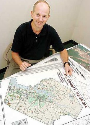
Cartography, or the art of mapmaking, has been around for hundreds of years. But the kind of maps Mark Lane makes are much different than the scrolling maps of days past. Lane, Hall County’s Geographical Information Systems manager, makes maps using many different formats and types of data. "Virtually every (Hall) county department uses our data in one way or another," Lane said. For example, Lane’s department makes a map for the sheriff’s office every month, using color-coded dots to represent where felonies were committed throughout the county. And Lane made a map for fire services that color coded the streets within a five-mile radius of the new fire stations. But you don’t have to be a government employee to use the county’s geographical information services. "We do maps for the public quite often," Lane said. Lane said he has worked with real estate companies and engineers to produce maps of various properties using aerial photography and contour lines. A map viewer also is available on Hall County’s Web site, which is a very popular feature, he said. Another function of the department is managing Hall County’s address database. "Any time a new subdivision is developed, we do all the addressing," Lane said. Hall County’s geographical information department was established in 1998. Lane had worked for Planning and Zoning since 1981, and had an extensive knowledge of the county when he took the position as the head of the new department. Lane graduated from University of West Georgia in Carrollton with a degree in geography, and said Geographical Information Systems is a great fit for him. "I’ve always enjoyed working with computers and looking at maps. This job combines those two elements," Lane said. He said he also enjoys what he does because it is gratifying to be able to provide useful, practical information to others. Geographical Information Systems can be reached at 770-531-6809.
Meet your government: Cartographer gives county maps a boost