
Northeast Georgia hiking trails
- Amicalola Falls State Park, 418 Amicalola Falls Lodge Road, Dawsonville
- Blood Mountain with parking available at the Byron Reece Memorial Trailhead on U.S. 19 near Blairsville
- Panther Creek Trail, trailhead at Old Historic U.S. 441, Clarkesville
- Raven Cliff Falls, trailhead on Richard B Russell Scenic Highway, Helen
- Sawnee Mountain Preserve, 4075 Spot Road, Cumming
- Tallulah Gorge Hurricane Falls Trail, 338 Jane Hurt Yarn Road, Tallulah Falls
- Yonah Mountain, trailhead Ga. 75, Cleveland
Whether you’re an avid hiker, strapping on a backpack weekly and hitting the trail or a beginner interested in stretching your legs, Northeast Georgia has endless opportunities to hike.
From a 6-mile scale of Blood Mountain on the Appalachian Trail to the 2 miles of trail at Sawnee Mountain Preserve, this region has a little bit of everything. Below is a list, in no particular order, of seven of the best hikes in Northeast Georgia.
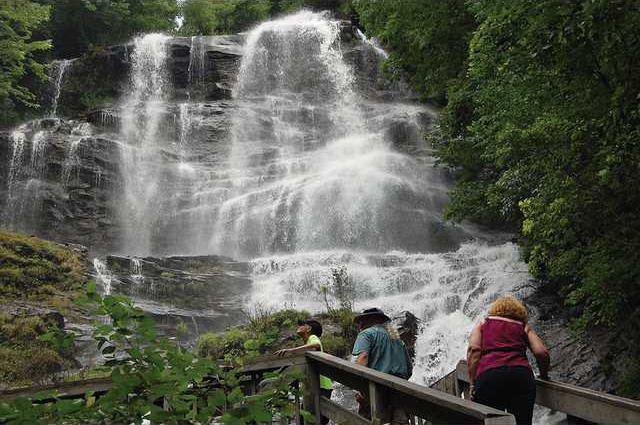
AMICALOLA FALLS STATE PARK
Located in Dawsonville, Amicalola Falls State Park is best known for the waterfall itself — the tallest east of the Mississippi River.
The park is a popular starting place for avid hikers, as the Appalachian Approach Trail departs from the falls to the Spring Mountain Summit, where the Appalachian Trail officially begins.
But those interested in viewing the falls without hopping on the approach trail can do so. The Amicalola Falls loop can be started from the top of the falls or the bottom, under a stone arch where many begin their Appalachian journey.
More than 600 stairs reach from the base of the falls to the ridge at the top, crossing a bridge over the middle. The loop is just more than 2 miles, but don’t underestimate the challenge of all those stairs.
BLOOD MOUNTAIN
In nearby Blairsville, a bit further along the Appalachian Trail, is Blood Mountain, the highest summit on Georgia’s portion of the famous trail.
The Blood Mountain loop trail covers 6 miles, beginning typically with the Byron Reece Trail on U.S. 19. The Byron Reece Trail connects to the Appalachian, covering some boulder-filled forest trails and reaching spectacular views and a rustic shelter at the mountain’s summit.
Locating the Byron Reece trailhead can be tricky, though not impossible. Parking at the Byron Reece Memorial Trailhead is available on U.S. 19, a few miles past the Walasi-Yi Center in Blairsville.
Access to the Appalachian Trail is also available just across the street from the center.
PANTHER CREEK TRAIL
Panther Creek Trail in Clarkesville crosses nearly 7 miles of creek, passing a series of waterfalls before reaching Panther Creek Falls and its pool beneath.
Though lengthy, the hike is not strenuous. The trailhead is just opposite the parking area on Historic U.S. 441 in Clarkesville, and the trail is popular for its campsites along the way. All sites are first-come, first-camp.
Note: An alternate approach is available from an eastern trailhead near Yonah Dam, which is much closer to the falls. But the trail is far more challenging, and should likely only be attempted by strong hikers and climbers.
RAVEN CLIFF FALLS
A personal favorite, the 5-mile hike at Raven Cliff Falls has a little of everything. About 2 ½ miles of shady, forest trail follow a stream and a series of falls before reaching the 40-foot-tall waterfall slicing through rock cliffs.
Word of advice: It’s worth crossing the water where you can for additional views and angles, but the wet rocks can be slippery. Cross with caution.
As a bonus, consider visiting the nearby Dukes Creek Falls, a short 1 mile, paved hike south of the Raven Cliff Falls trailhead on Ga. 348.
SAWNEE MOUNTAIN PRESERVE
If 5-mile hikes across water and bridges sound too strenuous, head a little bit south to Cumming’s Sawnee Mountain Preserve at 4075 Spot Road.
A 2-mile hike to the Indian Seats, a rock formation adjacent to an observation deck, offers beautiful views, especially in the fall as leaves change color.
Those interested in an even shorter approach to the top can park at the Bettis Tribble Gap parking lot, about three-fourths of a mile from the top.
Important note: No pets are allowed at the preserve or on its trails.
TALLULAH GORGE HURRICANE FALLS TRAIL
A very different experience of about the same length is available at Tallulah Gorge State Park.
The park’s Hurricane Falls Trail stretches more than 2 miles, but offers the best the park has to offer. It hugs the rim of the gorge rim, crosses a suspension bridge to the Hurricane Falls waterfall and enters the gorge floor.
Views from 10 overlooks are available on the trail, which departs from the Tallulah Gorge Interpretive Center, at 338 Jane Hurt Yarn Road, Tallulah Falls.
YONAH MOUNTAIN
Finally, a well-known mountain in Northeast Georgia offers a total 4.4 mile in-and-out hike on the Yonah Mountain Trail in Cleveland.
The hike is not the longest in the area but it is moderately strenuous, climbing quickly in elevation and requiring some hand-and-foot climbing at times. But the endless views from the summit are hard to beat.